12:00 PM | Possible early clues for another snowy and cold winter in the Northeast US
Paul Dorian

Overview
The summer is just days old, but it is never too early to look for clues regarding possible weather conditions for the upcoming winter season. In reality, the long descent towards winter 2015-2016 has just begun as far as the sun is concerned with daylight hours now entering its gradual diminishing phase in this part of the world. There are, in fact, two regions in the all-important Pacific Ocean that may be providing us with signs as to what kind of weather we can expect here in the Northeast U.S. during the upcoming winter season.
One region is in the equatorial Pacific Ocean where El Niño conditions are currently quite concentrated near the northwest coast of South America. These warmer-than-normal sea surface temperatures, however, actually stretch in a general west-to-east fashion along the equator from the northwest coast of South America to the central Pacific Ocean (indicated below by arrow). Another area of interest lies across the northern Pacific Ocean where a couplet of warm and cold sea surface temperature (SST) anomalies currently exists (circled area). These two regions in the Pacific Ocean may very well be indications that we’re headed for another snowy and cold winter in the Northeast U.S.

[Recent SST global anomaly map; courtesy NOAA]
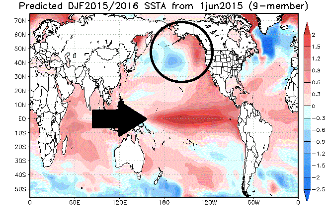
JAMSTEC SST anomaly forecast for the upcoming winter season
There are many reasons to believe that the current El Niño in the tropical Pacific Ocean will not only last into the latter part of 2015, but will actually strengthen throughout the summer months before most likely beginning a weakening phase near the end of 2015 or early in 2016 (for more info on this unfolding El Niño: http://vencoreweather.com/2015/05/14/915-am-strengthening-el-nino-in-the-tropical-pacific-ocean-to-have-global-ramifications/). Not only is the strength of an El Niño an important factor in terms of its potential impact on Northeast U.S. winter weather, but its location is critical as well. A reliable computer forecast model from Japan’s Agency for Marine Earth Science and Technology (JAMSTEC) predicts El Niño will shift from near the west coast of South America to the central Pacific Ocean by next winter (indicated below by arrow). This particular location for an El Niño in the central tropical Pacific Ocean has been correlated with snowy winters in the Northeast U.S. – most recently during the winters of 2002-2003 and 2009-2010.
[JAMSTEC predicted SST anomalies for winter 2015-2016; courtesy Japan’s Agency for Marine Earth Science and Technology]
In addition, the JAMSTEC SST anomaly prediction for next winter suggests there will be a continuation of the current couplet of warmer and colder-than-normal water in the northern Pacific Ocean (circled area above). The warmer-than-normal water south of the Alaska coastline has, in fact, persisted relentlessly for the past couple of years and has contributed to colder-than normal weather here in the Northeast US during the last couple of winters.
Consequences of the predicted SST anomaly pattern in the Pacific Ocean
During winter seasons, the sea surface temperature anomaly couplet in the northern Pacific Ocean generally has led to a persistent upper-level ridge of high pressure along the west coast of the US and Canada and an upper-level low in the north-central Pacific Ocean – usually an atmospheric combination that promotes colder-than-normal weather around here by allowing for the transport of Arctic air from northern Canada into the northern US. Meanwhile, an El Niño focused in the central Pacific Ocean often has been correlated with above-normal snowfall in the Northeast U.S. – most recently during the winters of 2003-2003 and 2009-2010. One of the possible reasons for this outcome is that warmer-than-normal sea surface temperatures in the tropical Pacific Ocean during wintertime tend to produce abundant moisture levels in the southern branch of the upper-level jet stream which is often a key player in Northeast U.S snowstorms.
Comparison with two snowy winters (2002-2003, 2009-2010)
Some rather amazing similarities exist between the JAMSTEC forecasted sea surface temperature anomalies for the upcoming winter season and the actual anomalies that took place during the snowy winters of 2002-2003 and 2009-2010. Not only do they both feature "centrally-based" El Niño’s in the tropical Pacific Ocean (indicated below by arrow), but they both have a noticeable SST couplet with a warm anomaly pattern tucked in near the Alaska coastline and a colder-than-normal region just to its southwest (circled area).

[Actual SST anomaly pattern during the winter seasons of 2002-2003, 2009-2010; courtesy NOAA]
What could change this preliminary snowy and cold winter outlook?
One way meteorologists track the strength of an El Niño is through an “oceanic Niño” index value. The latest 3-month running average of this index has risen from 0.2 in August/September/October of last year to 0.7 in March/April/May in this year. Generally, if this index rises above 2.0, the El Niño is considered to be in the “super strong” category. The last time a “super strong” El Niño actually took place was during 1997-1998, but there are some important differences between today's overall setup in the tropical Pacific Ocean and the situation back in the late 1990s. Specifically, there is a ring of warm water today surrounding much of the Australian continent and this usually has an inhibiting effect on the strength and longevity of an El Nino. If, however, a super strong El Niño were to develop by next winter across the central and eastern tropical Pacific Ocean, then this could very well flood much of the country including the Northeast U.S. with warmer-than-normal weather conditions. While I do expect this El Niño to become fairly strong – perhaps in the 1.5–2.0 index value range – I don't think it’ll rise to “super strong” levels seen last in the 1997-1998 time period and I also believe it’ll be focused in the central part of the tropical Pacific Ocean by next winter.
Concluding remarks
We’ll continue to monitor both the strength and location of the strengthening El Niño in the tropical Pacific Ocean over the next few months here at “vencoreweather.com”. As of right now, there are reasons to believe that there will be a centrally-based, moderately-strong El Niño as we head into the winter months of 2015-2016 along with a couplet of warm and cold anomaly water in the northern Pacific Ocean – all of which could lead to another snow-filled and cold winter in the Northeast U.S.
Paul Dorian
Vencore, Inc.